
13 February 2023
3Y0J – Never Give Up!
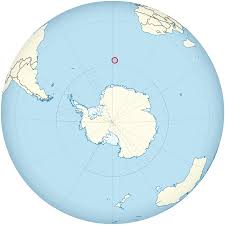 Bouvet Island: The Most Remote Island in the World!
Briefly about Bouvet Island:
Bouvet Island ( Norwegian: Bouvetøya) is an uninhabited sub- antarctic volcanic island in the South Atlantic Ocean, south-southwest of the Cape of Good Hope (South Africa). It is a dependent area of Norway and is not subject to the Antarctic Treaty, as it is north of the latitude below which claims are suspended.
Bouvet Island is located at . It is 58.5 km² (22.6 square miles) in area, 93% of which is covered by glaciers which block the south and east coasts. It has no ports or harbors, only offshore anchorages, and is difficult to approach. The easiest way is with a helicopter from a ship. The glaciers form a thick ice layer falling in high cliffs into the sea or onto the black beaches of volcanic sand. The 29.6 km (18.4 miles) of coastline are often surrounded by an ice pack. The highest point on the island is called Olavtoppen, whose peak is 780 m (2,600 ft) above sea level. A lava shelf on the island’s west coast, which appeared between 1955 and 1958, provides a nesting site for birds.
Bouvet Island is a candidate for the most remote island in the world, along with other small isolated islands such as Tristan da Cunha, Easter Island and the Pitcairn Islands. The nearest land is Queen Maud Land, Antarctica, over 1,600 km (1,000 miles) away to the south, which is itself uninhabited.
Bouvet Island was discovered on January 1, 1739, by Jean-Baptiste Charles Bouvet de Lozier, who commanded the French ships Aigle and Marie. However, the island’s position was not accurately fixed and Bouvet did not circumnavigate his discovery, so it remained unclear whether it was an island or part of a continent.
The island was not sighted again until 1808, when it was spotted by one Lindsay, the captain of the Enderby Company whaler Swan. Though he didn’t land, he was the first to correctly fix the island’s position.
The first successful landfall dates to December 1822, when Captain Benjamin Morrell of the sealer Wasp landed, hunting for seals. He was successful and took several seal skins.
On December 10, 1825, one Captain Norris, master of the Enderby Company whalers Sprightly and Lively, landed on the island, named it Liverpool Island, and claimed it for the British Crown.
In 1898, the German Valdivia expedition of Carl Chun visited the island but did not land.
The first extended stay on the island was in 1927, when the Norwegian “Norvegia” crew stayed for about a month; this is the basis for the territorial claim by Norway, who have named the island Bouvetøya (Bouvet Island in Norwegian). The island was annexed on December 1, 1927, by a Royal Norwegian Decree of January 23, 1928, Bouvetøya became a Norwegian Territory. The United Kingdom waived its claim in favour of Norway the following year. In 1930 a Norwegian act was passed that made the island a dependent area subject to the sovereignty of the Kingdom (but not a part of the Kingdom).
In 1964, an abandoned lifeboat was discovered on the island, along with various supplies; however, the lifeboat’s passengers were never found.
In 1971, Bouvet Island and the adjacent territorial waters were designated a nature reserve. In the 1950s and 1960s, there was some interest from South Africa to establish a weather station, but conditions were deemed to be too hostile. The island remains uninhabited, although an automated weather station was set up there in 1977 by the Norwegians.
On September 22, 1979, a satellite recorded a flash of light (which was later interpreted as having been caused by a nuclear bomb explosion or natural event such as a meteor) in a stretch of the southern Indian Ocean between Bouvet Island and Prince Edward Islands. This flash, since dubbed the Vela Incident, is still not completely resolved.
Despite being uninhabited, Bouvet Island has the Internet country code top-level domain ( ccTLD) .bv, though it is not used. A handful of amateur radio expeditions have gone to this remote location ( call signs used here begin with 3Y). Bouvet Island falls within the UTC Z time zone. Atlantic/St_Helena is the zone used in the time zone database.
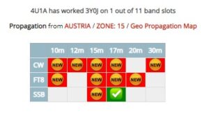
 On the eve of the arrival of the 3Y0J expedition (Top #2 DXCC most wanted) to the Bouvet island, a natural disaster occurred in Vienna. The strongest wind severely damaged our Yagi 20-15-10m Yagi antenna and the station was left with only two EFHW beams for 80-160m and 40-80m. We gave up hope for at least one QSO with the expedition, because it was no longer realistic to communicate with it with such antennas.
It was not possible to repair the Yagi antenna in a short time.
But, the persistence of the Club team and the initiative prevailed…
After a short Club meeting, we decided to install the “Inverted-Vee” antennas for 40-20m and 30-18m bands on two light 6m masts.
On the evening of February 12th, after several attempts, within 5 minutes, QSO was made with 3Y0J !
 NEVER GIVE UP!